- Blog more
- Spend more time outdoors
- Be more fit.

Wednesday, 4 January 2012
My New Years Resolutions
Everyone has Resolutions this time of year. Mine are pretty simple:

Saturday, 15 October 2011
Guadalupe Mountains: Permian Basin Geology Field Course
I spent last week in the Guadalupe Mountains around Carlsbad, NM with a group of co-workers ranging in expertise from Geologists to Engineers. The purpose of our trip was to better understand the geology of the Permian Basin as it applies to oil and gas production in the subsurface. Since I have gone fairly in depth in the past on this area when my wife and I came over to the more touristy areas like Carlsbad Caverns I will make this post a photo journal of our trip instead of a long exposition.
 |
| Looking at gypsum and dolomite varves in the Castile Formation. |
 |
| Creative graffiti on this piece of Permian age reef |
 |
| Excellent exposure of Crinoid stem fossils |
 |
| Exposed gastropod, not sure of the species |
 |
| Hiding from the recent flash floods, see the mudline? |
 |
| We found this guy hiding from the heat in a small grotto |
 |
| View to the west from the Escarpment. To the left you can see part of the Brokeoff Moutains |
 |
| Another view to the West from a small side canyon |
 |
| A Horny Toad! He just flattened out and refused to move. |
 |
| You have no idea how much the wind was blowing. See the rain coming in from the north behind me? |
 |
| A Huge barrel cactus colony! |
 |
| A view from the highway of the hills near Van Horn, TX. All this land is owned by the owner of Amazon.com |
 |
| The Chinese Hat (previously know as The Breast of Venus). Every time I go to Carlsbad I want to touch this thing... |
 |
| Maybe one day when I'm a Big Boy I can be a Park Ranger |
 |
| Checkin' what's under the skirt in White City |
 |
| Excellent fossil reef exposure near White City, in the middle of the picture... a Neptunian Dike. Make your own joke. |
 |
| View of the Shadduck Escarpment from Dog Canyon Camp Ground in the north side of Guadalupe NP. |
 |
| Sunset over the Indian Basin |
 |
| Fantastic road cut of the Castile gypsum between Carlsbad, NM and Pine Springs, TX |
 |
| My favorite picture of Capitan Reef. Taken from a rest area south of the park. |
 |
| Most of our geology group, wearing our stylish safety vests. |
Wednesday, 28 September 2011
Labor Day Weekend: Fort Davis National Historic Site (62)
N 30° 35.640 W 103° 56.707
We woke up early and had a great breakfast at the Indian Lodge restaurant. I chose eggs cooked to order and bacon, while my wife braved the enormous "short stack" of homemade buttermilk pancakes. I think she maybe ate half of it, they filled her plate! Afterwards we decided to take an early morning hike up the trail that starts just behind the Lodge and goes up to the bluffs above. We didn't see any javelina this morning, and with no breeze in the canyon we were eager to get to higher elevations.
 |
| A rest at the top of the bluff |
I was eager to make my way up to the bluffs that rise behind the Lodge as there was a geocache there that had not been found in over a year since it had been hidden. I also knew another geocacher, grumpyoldtexan, was planning to attempt this cache again today. Even though it was still early the temperature was quickly rising and you are almost in a box canyon at the trail head so there was little to no breeze. Luckily, once we reached the ridgeline a fair breeze was blowing which made the hike much more enjoyable. About half way up we ran into grumpy and his wife as I seached for another tough geocache and from there on we teamed up to finally find this elusive hide. With four sets of eyes, a leap of faith, and determination we did indeed find the cache after a fifteen minute search of ground zero.
 |
| View of the Indian Lodge from the bluffs above |
Returning from our hike we checked out of the Lodge and drove down to Fort Davis NHS. This is the 62nd National Park Unit that we have visited. It is not a very large park but it isn't near the smallest one we have been to before. (That would be Minuteman Missle which is only a single Cold War era nuclear missile bunker and silo.) We were greeted right away by a very friendly Ranger asking if we would like our picture taken together. This is a rare thing for us, most of our photos are of one or the other at the places we visit, because we travel alone mostly. We took her up on her generous offer and got an excellent shot with the large special occasion parade flag in the background. We then went to the theater and watched a short film on the history of the fort narrated by Kareem Abdul Jabar of all people. My wife had no idea who he was but I cracked up when he walked on screen in full regalia. We then stamped out National Parks Passport in the visitor center and walked around the grounds. I really enjoyed our short stop here, and hope to return in cooler weather.
 |
| Fort Davis National Historic Site |
One last thing I wanted to mention was Murphy's Pizzeria at 107 Musquiz Dr. in Fort Davis. They came heavily recommended to us by grumpyoldtexan earlier in the day so we decided to stop for a bit. It is very tasty pizza with a super thin cracker-like crust. The toppings are all fresh and they have all you could think to had to a pizza. Although we did not order a salad I saw several brought to other customers and those looked amazing too, loaded with all kinds of toppings in very large bowls.
 |
| Tree in the patio at Murphy's Pizzeria |
Thursday, 22 September 2011
Labor Day Weekend: Davis Mountains State Park & McDonald Observatory
Sorry to delay posting the rest of our Labor Day trip. Sometimes RL "real life" gets in the way.
After a day of swimming at awesome Balmorhea State Park we had to cover some ground to get to The Indian Lodge in Davis Mountains State Park where we had a reservation for the night. Now the funny thing is I never intended to go to the Davis Mountains on this trip when I booked a room I thought the Lodge was in Balmorhea, oops... But happy accidents and all that, and we found ourselves there in the late evening. It was more than we had expected having stayed in many state park lodges in many states, the Indian Lodge is a beautiful adobe conglomeration of loosely connected rooms, breezeways, and different levels with great views of the valley. It was one of many structures built by the CCC in the park and we would highly recommend it. We ate dinner at the on-site restaurant which serves diner style Tex-Mex, it is reasonably priced and while it isn't the best place I have ever eaten it was certainly palatable after the long hours of swimming.
 |
| Courtyard at the Indian Lodge |
Later after checking in and having dinner we decided to drive the Skyline road to grab a couple geocaches, but more so to see the fire damage and great a better look at our surrounding in general. The day was warm but a stiff breeze made it pleasant enough to drive with the windows down. From the crest of the road the 360 degree views are quite amazing. What shocked me most was that although the fires were widespread and devastating here there is new green growth to be seen everywhere. There hasn't been much more rain since the fires, but burned-out yucca and mesquite have new green sprouts and the ground is covered in little flowers. Even the pinons have new green needles it seems! The worst we saw of the fires was the destruction of the historic picnic area at the overlook. It has lost its roof and been cordoned off. Also, there are many antenna array up top that I assume are weather stations and temporary cellphone towers. Cell reception is poor at best and absent except on the highest points.
 |
| Wild Javelina in Davis Mountains State Park |
 |
| Historic Picnic Area on Skyline Drive |
 |
| Greenery and life returns to the Davis Mountains |
Dusk was falling, quick as ever when you are in mountainous terrain, we could see the McDonald Observatory in the distance from Skyline drive and decided on the fly to go check it out. Neither of us had ever been to a star party before, all I knew is I shouldn't drink any Kool-Aid offered by the host. It seemed to take a long time to get to there even though it was just over six miles as the crow flies because the road does anything but go straight between the park and the observatory. First we headed west, the north, and lastly we almost passed the observatory before turning off the highway and looping back around to the visitor center. We bought our tickets for the star party and sat outside watching the hummingbirds fly around in the waning light. As it turned out the clouds did not blow off as much as we would have hoped so they gave a "virtual star party" presentation in the theater and then let us take turns looking through the many telescopes behind the visitor center looking at fleeting star clusters and galaxies, nebulae, etc. peeking out of the clouds. The highlights of the evening were seeing the International Space Station pass over head and seeing several shooting stars. The moon was also visible as a waning crescent. My take home though was that I really want a green laser pointer, those things have amazing range!
 |
| Sunset at the McDonald Observatory |
Thursday, 8 September 2011
Product Review: Vibram FiveFingers Komodo Sport LS
I have heard a lot about Vibram FiveFingers over the last few years. At first I only knew one person that had them, but now I know several and see them around quite often especially in the geocaching community which tends to have a larger proportion of outdoor types than the general populous. For mixed outdoor use the KSOs have always been the tried and true model, but there are a new line of FiveFingers that claim to offer the unique ground feel of a individually pocketed toe shoe while providing even more traction and control. Enter the Komodo Sport LS.
 I walked into the only store in Midland that sells FiveFingers, Run this Way, with only a vague idea of what I wanted. I had never tried on these shoes before, so I had to be sized as they run according to European sizing. According to the guide my 11.5 US sized feet fit a 43 EUR. I tried on the KSOs first and while I liked the general fit they only had bright red ones left as they are being discontinued. I wanted something a bit more muted; they tend to draw enough attention without the addition of bright colors! Next, I tried on the Trek boots. Instead of the lightweight fabrics most FiveFingers are contructed from, these are made of a thin leather material. The soles are a bit thicker which allows for more heavy terrain handling, but the downside is that the toes are much stiffer. I could not get my stubborn little toe into its compartment despite many tries.
Lastly, I found the Komodo Sport LS in Castle Rock coloring. I like the light weight of the shoe and the raised tread on the sole. The quick lacing system secures the shoe against grit and stone while the velcro fastener keeps the laces from flopping around and collecting debris. Once you guide your big toe into the first spot all the others find their way with little manipulation. But the true test came later on in the Davis Mountains when I was able to get on trail in these unique shoes. The retail price for the Vibram FiveFingers Komodo LS is $110.
 I had worn my Komodos around town a bit to get the feel of them. I am very flat footed so I was worried my feet would really ache after a little while with the thin and mostly unpadded sole. However I found them comfortable for the most part. One thing I noticed was pressure in the middle of my foot after standing still for prolonged periods of time on level terrain. The Davis Mountains were a different story though. Once I left the parking area behind the Indian Lodge and started up the trailhead everything I thought about these shoes changed. I could feel every rock and pebble beneath my feet like being barefooted but there was no discomfort. I walked over a few boulders and felt the soles of the Komodos grip the rock. I even climbed a live oak looking for a geocache.

The shoes respond to what you are standing on while allowing you the foot feel to know its there. The last thing I wanted to see was how these shoes handled a little bouldering. There was a cache on top the bluffs overlooking the Lodge that had gone unfound for months. With few clues to go on me and another cacher I met on the trail started searching. I searched high while he went low, and after fifteen minutes or so the cache was found on a rocky outcropping part way down a close to vertical cliff face. Stepping from one rock ledge to another I could feel the rock with my tiptoes and actually curl my toes around the ledge. This is something that is impossible with any other shoe I've ever worn. At the end of the day despite several miles of hiking with no socks and thin tight fitting shoes I had no blisters at all.

I love these shoes, I want more already, maybe giving the Treks another shot as I would love a thick soled version for true off trail hiking. The only test I haven't done is to see what happens when a mesquite thorn finds its way into my sole. I'm not eager to see or feel the result. Also, I don't recommend these shoes for casual wear in town, the sheer flatness does start to ache your feet after standing around for extended periods.

 I walked into the only store in Midland that sells FiveFingers, Run this Way, with only a vague idea of what I wanted. I had never tried on these shoes before, so I had to be sized as they run according to European sizing. According to the guide my 11.5 US sized feet fit a 43 EUR. I tried on the KSOs first and while I liked the general fit they only had bright red ones left as they are being discontinued. I wanted something a bit more muted; they tend to draw enough attention without the addition of bright colors! Next, I tried on the Trek boots. Instead of the lightweight fabrics most FiveFingers are contructed from, these are made of a thin leather material. The soles are a bit thicker which allows for more heavy terrain handling, but the downside is that the toes are much stiffer. I could not get my stubborn little toe into its compartment despite many tries.
Lastly, I found the Komodo Sport LS in Castle Rock coloring. I like the light weight of the shoe and the raised tread on the sole. The quick lacing system secures the shoe against grit and stone while the velcro fastener keeps the laces from flopping around and collecting debris. Once you guide your big toe into the first spot all the others find their way with little manipulation. But the true test came later on in the Davis Mountains when I was able to get on trail in these unique shoes. The retail price for the Vibram FiveFingers Komodo LS is $110.
 I had worn my Komodos around town a bit to get the feel of them. I am very flat footed so I was worried my feet would really ache after a little while with the thin and mostly unpadded sole. However I found them comfortable for the most part. One thing I noticed was pressure in the middle of my foot after standing still for prolonged periods of time on level terrain. The Davis Mountains were a different story though. Once I left the parking area behind the Indian Lodge and started up the trailhead everything I thought about these shoes changed. I could feel every rock and pebble beneath my feet like being barefooted but there was no discomfort. I walked over a few boulders and felt the soles of the Komodos grip the rock. I even climbed a live oak looking for a geocache.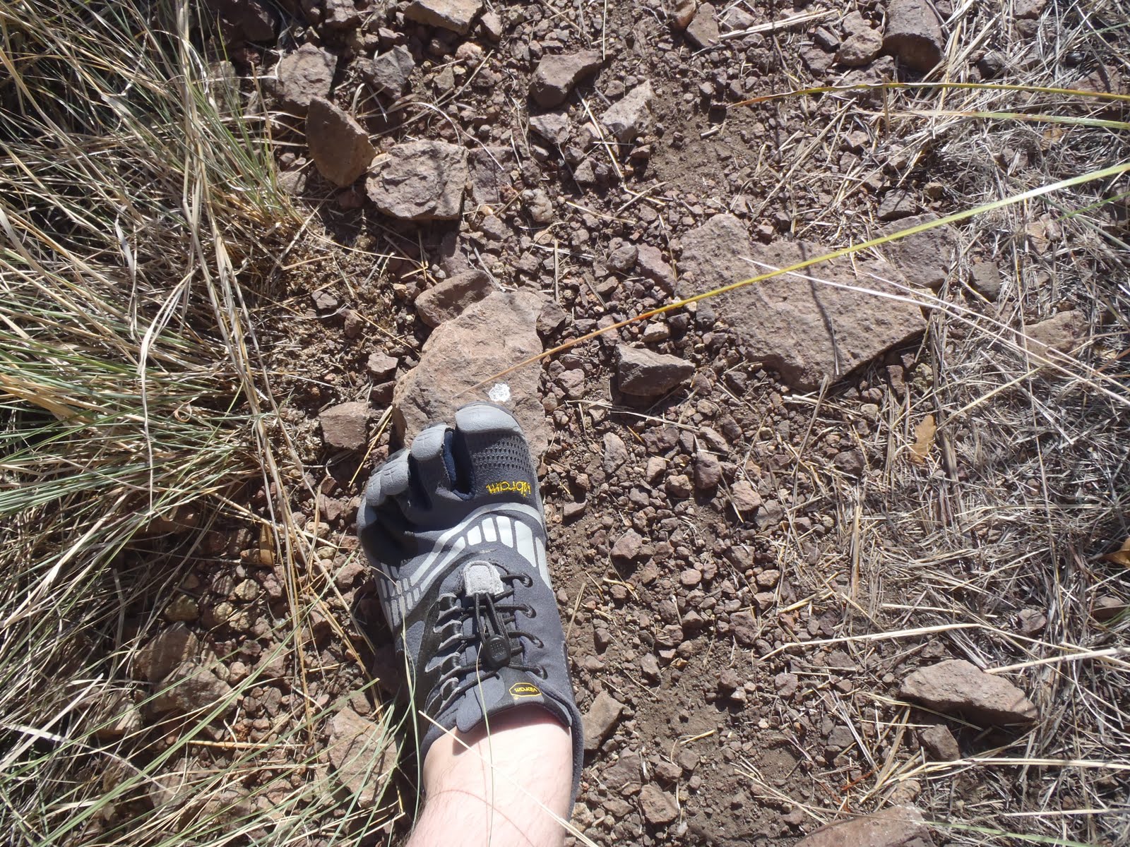
The shoes respond to what you are standing on while allowing you the foot feel to know its there. The last thing I wanted to see was how these shoes handled a little bouldering. There was a cache on top the bluffs overlooking the Lodge that had gone unfound for months. With few clues to go on me and another cacher I met on the trail started searching. I searched high while he went low, and after fifteen minutes or so the cache was found on a rocky outcropping part way down a close to vertical cliff face. Stepping from one rock ledge to another I could feel the rock with my tiptoes and actually curl my toes around the ledge. This is something that is impossible with any other shoe I've ever worn. At the end of the day despite several miles of hiking with no socks and thin tight fitting shoes I had no blisters at all.

I love these shoes, I want more already, maybe giving the Treks another shot as I would love a thick soled version for true off trail hiking. The only test I haven't done is to see what happens when a mesquite thorn finds its way into my sole. I'm not eager to see or feel the result. Also, I don't recommend these shoes for casual wear in town, the sheer flatness does start to ache your feet after standing around for extended periods.

Tuesday, 6 September 2011
Labor Day Weekend: Balmorhea State Park
We decided to take a short two-day vacation for Labor Day weekend and explore some new Texas State Parks we haven't been to yet. I've been puzzling over which parks to visit in warm weather and which to save for the fall and winter. Balmorhea was top of the list for a late summer visit because it is all about the pool! From Midland the drive takes about two and a half hours, once you turn south and the Davis Mountains begin to loom in front of you, you know you are close.
N 30° 56.279 W 103° 49.654
Just west of the park is an old church I likely would have never known about if not for geocaching. The back wall preserves the original adobe and even mid-day on a Friday there were half a dozen or so prayer candles burning. From the cache page:

N 30° 56.747 W 103° 47.009
After paying our $7 per person entry fees we drove over to the historic cienega and checked out the exhibit on the natrual wetlands that once covered a much larger area of the park before the CCC built the swimming pool in 1935. In creating the natural pool they destroyed the wetlands that the springs here fed, now they have been restored in part and are home to at least two endangered species. We found the official Texas State Parks cache for Balmorhea and spent some time looking through the viewing windows at the fish in the surprisingly clear water. It was getting hot so we left the wetlands for the pool!

One of the most unexpected encounters we had at Balmorhea was with the bats. In the cienega viewing area we first spotted a small dead bat on the ground. Once we made our way to the pool there were many more bats to be found although we never saw a single one. The building that houses the public restrooms and changing area is absolutely infested with bats! If you stand in the breezeway to the ladies room you'll here their high pitched squeaks in the rafters. There are also the tell-tale signs of guano and urine on the ground in the cracked beams and adobe. Then there is the smell. It isn't as overpowering as some caves I have been in but the ammonia smell is unmistakable. I am sure if you hung around here until dusk you would be rewarded with a good show as there seems to be a large colony.

The pool.... it is one of the coolest places I have ever been to swim. The surface is finished like two conjoined Siamese Olympic pools complete with ladders and diving boards. However, the big difference between this pool and any normal pool is that it is around thirty feet deep at its deepest, the bottom is all natural bedrock and spring fed, and lastly... THERE ARE FISH! Minnows, fish, large catfish, turtles even. There were swimmers of all ages, and towards the end of our stay three scuba divers even showed up. The whole facility is very clean and well maintained while keeping a rustic sort of feel to it.

After getting pruned fingers, meeting new fishy friends, and doing some high dives (for Science!) we packed up for a thirty minute drive to Davis Mountains State Park where we had accidentally booked a room at the Indian Lodge thinking it was at Balmorhea State Park. In the end it was a happy accident as we had a great time there the next day. At a road side historical marker I struck out on the cache I was hunting but found this three and a half foot long rattlesnake skin!

N 30° 56.279 W 103° 49.654
Just west of the park is an old church I likely would have never known about if not for geocaching. The back wall preserves the original adobe and even mid-day on a Friday there were half a dozen or so prayer candles burning. From the cache page:
Written records for Mission Mary began in 1902, when a thirty four year old priest from the Netherlands started recording baptisms and marriages. Father Nicolas Brocardus arrived in the United States in 1892 and started serving the Big Bend in 1897. At first Father Brocardus rode the circuit on horseback or in a buggy, later in a Ford Model T. Father Brocardus made his rounds about once a month , at that time baptisms and marriages were performed.Like all growing communities Calera residents eventually decided that they needed a church building, the structure was made of adobe and rock. Although the community was financially poor they banded together to construct the adobe structure( see Lupe Renteria's Story). This original building served the community until the late1930s or early 1940s when the diocese that was building a new church in Brogado plastered the original adobe building. Since Calera never grew into a large community it remained a mission first served by Father Brocardus from Saint Josephs Parish in Fort Davis. Later responsibility for Mission Mary fell on the priest from Brogado. Mission Mary was eventually abandoned and only the Church at Brogado remained.

N 30° 56.747 W 103° 47.009
After paying our $7 per person entry fees we drove over to the historic cienega and checked out the exhibit on the natrual wetlands that once covered a much larger area of the park before the CCC built the swimming pool in 1935. In creating the natural pool they destroyed the wetlands that the springs here fed, now they have been restored in part and are home to at least two endangered species. We found the official Texas State Parks cache for Balmorhea and spent some time looking through the viewing windows at the fish in the surprisingly clear water. It was getting hot so we left the wetlands for the pool!

One of the most unexpected encounters we had at Balmorhea was with the bats. In the cienega viewing area we first spotted a small dead bat on the ground. Once we made our way to the pool there were many more bats to be found although we never saw a single one. The building that houses the public restrooms and changing area is absolutely infested with bats! If you stand in the breezeway to the ladies room you'll here their high pitched squeaks in the rafters. There are also the tell-tale signs of guano and urine on the ground in the cracked beams and adobe. Then there is the smell. It isn't as overpowering as some caves I have been in but the ammonia smell is unmistakable. I am sure if you hung around here until dusk you would be rewarded with a good show as there seems to be a large colony.

The pool.... it is one of the coolest places I have ever been to swim. The surface is finished like two conjoined Siamese Olympic pools complete with ladders and diving boards. However, the big difference between this pool and any normal pool is that it is around thirty feet deep at its deepest, the bottom is all natural bedrock and spring fed, and lastly... THERE ARE FISH! Minnows, fish, large catfish, turtles even. There were swimmers of all ages, and towards the end of our stay three scuba divers even showed up. The whole facility is very clean and well maintained while keeping a rustic sort of feel to it.
San Solomon Springs, near Balmorhea, is an oasis in arid West Texas. It's the sixth largest spring system in Texas. The springs have provided water for travelers for thousands of years. Earlier the springs were called Mescalero Springs for the Mescalero Apache Indians who watered their horses along its banks. It is believed the Jumano Indians irrigated their corn and peach trees from the spring. The present name was given by the first settlers, Mexican farmers, who used the water for their crops and hand-dug the first irrigation canals. Today the springs are in Balmorhea State Park in Toyahvale, Texas, and the tremendous flow of the springs (22 to 28 million gallons a day) is used to feed a large swimming pool. It's the largest (two-acre) and nicest spring fed swimming pool in Texas after Austin's Barton Springs.

After getting pruned fingers, meeting new fishy friends, and doing some high dives (for Science!) we packed up for a thirty minute drive to Davis Mountains State Park where we had accidentally booked a room at the Indian Lodge thinking it was at Balmorhea State Park. In the end it was a happy accident as we had a great time there the next day. At a road side historical marker I struck out on the cache I was hunting but found this three and a half foot long rattlesnake skin!

Tuesday, 30 August 2011
The Texas State Parks Geocache Challenge
 This past weekend I found myself in Big Spring, Texas for a Geocaching event. A while back I attended an event in Austin where the Texas State Park Service had a booth talking about this great geocaching passport program they would be starting up. I knew it was supposed to begin in June but not much else. As I began to plot the caches I wanted to find in Big Spring I ran across this Big Spring State Park cache. The park is small, and nestled in center of downtown Big Spring. Arriving at the front gate you find a small kiosk that mentions that there is no longer any overnight camping allowed in the park. It is strictly a day-use park! I found no place to pay an entry fee so I began a slow winding drive up to the top of the mesa on which the park is located.

To access the geocache you park in the small lot for the Nature Trail and bird observation area on your right as you drive into the park. From here it is about three tenths of a mile to the cache with a gradual elevation gain and occasional steps set into the trail. Although it was already about 90F at 10AM I found the walk very nice and easy on the legs and knees. The cache itself is an ammo can with various swag, a log book, some nice color illustrated fact cards about the state parks, and lastly a tethered orienteering punch. To complete the "Big Sky" State Park Challenge you need to find the appropriate geocaches in ten of the twenty parks in this region that includes North and West Texas. There are similar challenges for other regions in the state. There are handy passports to print out on the Texas State Parks website. Just find the cache, answer a question based on the information on the collectible cards in the cache and punch your passport with the orienteering stamp. It's that easy!
A few joggers passed me as I was checking out the cache, but they paid me no real attention. I like the location chosen for this cache as it is not a park and grab and requires a little effort to attain but I wish the container were a little better hidden. I fear it may disappear even though it is clearly marked because it is visible from the trail. Now that I have found my first GeoChallenge cache I am eager to visit more Texas State Parks. When you complete your passport you mail it to the park service for a certificate and a chance at various prizes.
Lastly I hiked over to the observation rim on the north edge of the park and took in a vista of Big Spring and the wind farms out in the distance. It is far from the best vista I have ever seen, but it is amazing how far you can see over the surrounding flat flat terrain. I completed my visit by doing a few of the new Geocaching Challenges. These involve no physical containers to find but rely on you going outdoors and recording yourself doing various activities. There is even a free app for iPhones to keep up with your challenges.
 Here my task was to take a photo of local landmarks with my finger on top of them. This was ackward to do alone but I took a photo of a large wind farm on another mesa to the east.

And here I was tasked with spelling out my Geocaching handle "ZSandmann" with native materials. I chose the abundant mesquite beans to leave my mark.
My wife and I are planning a trip to Balmorhea State Park for Labor Day. So look for that post soon!
Subscribe to:
Posts (Atom)