Showing posts with label national parks. Show all posts

Thursday, 13 September 2012

Summer is HOT, but Winter is Coming!

It's been a long while since I blogged. I blame the heat. It's been too hot to enjoy much of anything outside, geocaching, hiking, camping, you name it... The first cool "cold" front of the fall/winter season has encouraged me to post this blog. Hopefully more will be soon to follow. Thanks for checking back!

 Summer started off with a Geocaching Flash mob. I intended to make it duck themed but found out upon arrival that the park discourages feeding the ducks bread! Bummer, still a good time was had by all.

When we went home for the Fourth of July I saw the Mighty Mississippi at the lowest I have ever seen it. Sand bars were exposed that I've never seen, and the riverboat casino here in Vicksburg was completely beached!

 I said goodbye to my Toyota Tacoma "Blue" and got a 2012 Subaru Impreza Sport! Her name is Samantha, and she is a lot of fun to drive! I wish I could drive a stick though, a WRX would be even MORE fun!

 That's going to leave a mark!

 I seem to have moved from Phooning to Planking as my silly picture posture of choice. I blame the Internets! Here I am at the Buddy Holley Museum in Lubbock, TX

 This is Buddy's grave, pretty simple for a legend! In case you were wondering there are Virtual Caches at the museum and the grave site, no containers, so were very respectfully done. I honestly never would have come to this location without Geocaching.

 Ah Summer Mummers.... Beer through a straw, silly T-Shirt, and a popcorn bag crown. I don't even remember this being taken. Ha! SCIENCE!

 One of the few short trips we took. My In-laws came to visit so since Midland has nothing interesting to do I took a day off work and we went to Carlsbad Caverns and Guadalupe Mountains National Parks. A crazy-short trip but a lot of fun.

 Collaborate and Listen?

 "The night is dark and full of terrors" Ok that's two Game of Thrones quotes in this blog, I really need to get outside some more....

 My favorite Cavern formation. It went from being sexist "Breast of Venus" to racist "Chinese Hat" It speaks to me in some kind of way. I can't figure out why?

 I haven't seen a stick bug in forever! Here is one hanging out on the NPS sign at the Pine Springs Visitor Center in the Guadalupes.

It was very very hazy when we visited. The only hiking we did was a walk on the Butterfield Mail Stage Trail near Pine Springs. I would really love to come back and see McKittrick Canyon in the fall soon!

Tomorrow we leave for Brenham, TX for a Geocaching Event weekend. Look for a new post soon!

Wednesday, 28 September 2011

Labor Day Weekend: Fort Davis National Historic Site (62)


N 30° 35.640 W 103° 56.707 

We woke up early and had a great breakfast at the Indian Lodge restaurant. I chose eggs cooked to order and bacon, while my wife braved the enormous "short stack" of homemade buttermilk pancakes. I think she maybe ate half of it, they filled her plate! Afterwards we decided to take an early morning hike up the trail that starts just behind the Lodge and goes up to the bluffs above. We didn't see any javelina this morning, and with no breeze in the canyon we were eager to get to higher elevations.

A rest at the top of the bluff

I was eager to make my way up to the bluffs that rise behind the Lodge as there was a geocache there that had not been found in over a year since it had been hidden. I also knew another geocacher, grumpyoldtexan, was planning to attempt this cache again today. Even though it was still early the temperature was quickly rising and you are almost in a box canyon at the trail head so there was little to no breeze. Luckily, once we reached the ridgeline a fair breeze was blowing which made the hike much more enjoyable. About half way up we ran into grumpy and his wife as I seached for another tough geocache and from there on we teamed up to finally find this elusive hide. With four sets of eyes, a leap of faith, and determination we did indeed find the cache after a fifteen minute search of ground zero.

View of the Indian Lodge from the bluffs above
N 30° 36.006 W 103° 53.496 

Returning from our hike we checked out of the Lodge and drove down to Fort Davis NHS. This is the 62nd National Park Unit that we have visited. It is not a very large park but it isn't near the smallest one we have been to before. (That would be Minuteman Missle which is only a single Cold War era nuclear missile bunker and silo.) We were greeted right away by a very friendly Ranger asking if we would like our picture taken together. This is a rare thing for us, most of our photos are of one or the other at the places we visit, because we travel alone mostly. We took her up on her generous offer and got an excellent shot with the large special occasion parade flag in the background. We then went to the theater and watched a short film on the history of the fort narrated by Kareem Abdul Jabar of all people. My wife had no idea who he was but I cracked up when he walked on screen in full regalia. We then stamped out National Parks Passport in the visitor center and walked around the grounds. I really enjoyed our short stop here, and hope to return in cooler weather.

Fort Davis National Historic Site

One last thing I wanted to mention was Murphy's Pizzeria at 107 Musquiz Dr. in Fort Davis. They came heavily recommended to us by grumpyoldtexan earlier in the day so we decided to stop for a bit. It is very tasty pizza with a super thin cracker-like crust. The toppings are all fresh and they have all you could think to had to a pizza. Although we did not order a salad I saw several brought to other customers and those looked amazing too, loaded with all kinds of toppings in very large bowls.


Tree in the patio at Murphy's Pizzeria

Thursday, 14 July 2011

Random 4th of July Weekend Photos


This little guy (Melon) made the trip with us to his new home in Alabama.


View of the Mississippi River from Vicksburg Rest Area @ Navy Circle

Pandora reading up on her history

There was a lot of this over the long weekend

And some of this. I liked our team name.

Why yes this guy did have a 1980s era camcorder. And he was filming the signs with it, LOL!

A little red bird in the park

One of my favorite monuments at Vicksburg, very DC-esque

Found this park boundary marker being retaken by nature.

Tuesday, 12 July 2011

Vicksburg National Military Park - NPS Unit #61

In 2008 we visited Grant's Canal located in Delta, Louisiana in order to log a virtual geocache I needed to complete the Louisiana Delorme Challenge. This geocaching challenge requires you to find a cache on every page of the Delorme Atlas for a particular state. It is a fun way to explore parts of the state you would otherwise never reach. I knew at the time that this was a very small part of Vicksburg National Military Park but we didn't have time to visit the rest that day. In 1862 and 1863 the Union was trying desperately to seize control of the Mississippi River from the Confederates. Vicksburg with its high cliffs was nearly impossible to assault from the water so General U.S. Grant attempted to dig a canal through a bend in the river and thus bypass Vicksburg. After months of digging the dam holding back the river broke and the earthworks were flooded, the entire project was a failure.


Fastforward to 2011: We were on our way from Midland, TX to Tuscaloosa, AL to celebrate the 4th of July with family when we stopped at the rest area on the banks of the Mississippi River in Vicksburg. Navy Circle is just beside the rest area and was one of the anchor points of the Confederate defenses of the city. I was milling through pamphlets and saw that there were all kind of events going on in the NMP due to it being: The anniversary of the Confederate surrender of Vicksburg (July 3), a Holiday weekend, the 150th Anniversary of the Civil War, and the 25th Anniversary of the National Parks Passport Program. Although we didn't have time that day, I made it a goal to stop on our way home the following weekend.


On our return trip through Vicksburg we stopped at the very nice Visitor Center and Interpretive Museum where there are some reconstructions of the Civil War camps. Today they had reenactors in full uniform performing a variety of activities. After watching for a few minutes in the sweltering heat I made my way into the Visitor Center and walked through the displays and gift shop. Then we took the 16 mile park drive in our wonderfully air conditioned car. Agriculture from Reconstruction has changed the landscape a good bit but driving through the rolling hills and gullys you can see how suited the terrain was for a battlefield. I found myself picturing the best places to position cannon and infantry like a real-life game of Risk.


We visited the Shirley House which is the only original structure still in place and stopped at the USS Cairo Museum to see the only surviving Ironclad ship from the war that sank in the river when it hit a primitive Confederate torpedo (mine). The museum perserves a lot of artifacts recovered from the Cairo and is in my opinion even better than the museum in the main Visitor Center. Then we briefly drove through the Cemetery and returned back to the front of the park. I plan to return to Vicksburg in the winter when we travel home for Christmas, the weather should make it more tolerable to explore the outdoor areas more thoroughly then. But I feel we got a good feel of the park in our time spent here on this trip.


The Shirley House


Map of Vicksburg: Areas visited are circled red.

Saturday, 30 April 2011

McKittrick Canyon: Easter Weekend 2011 Part III

Easter Sunday we woke up in our tent to pleasant temperatures. The only discomfort was that our air mattress was a wee bit too small, it was made to fit in the bed of my truck where you can lay up against the sides of the bed. We packed up and broke camp then departed Pine Springs Campground to do some light Geocaching and one last trail hike in McKittrick Canyon.

The previous evening we had been stargazing and seen some smoke coming over the Guads, today that smoke was much more ominous so I asked in the Visitor Center about it and was told it was called the Last Chance Fire and was likely started by hikers making a campfire. (Why are people so ignorant sometimes?) After a brief chat with the Rangers about a lost campground host that had been found Friday night before we arrived we departed Pine Springs. The McKittrick Canyon Visitor Center is an unusual one as there are no Rangers stationed here, and the displays are outdoors in a covered pavilion. We looked these over a bit, and from the pictures I've decided we will likely return in the fall to see the trees change. I wanted to get the McKittrick Canyon Nature Loop Earthcache but there were signs the trail was a bit steep in places and both of our legs were Jell-O from our hike to Guadalupe Peak the previous day. So I made a quick backwards loop on the trail to gather the needed information while Steph filled water bottles and packed some snacks. Then we hit the trail to Pratt Cabin.

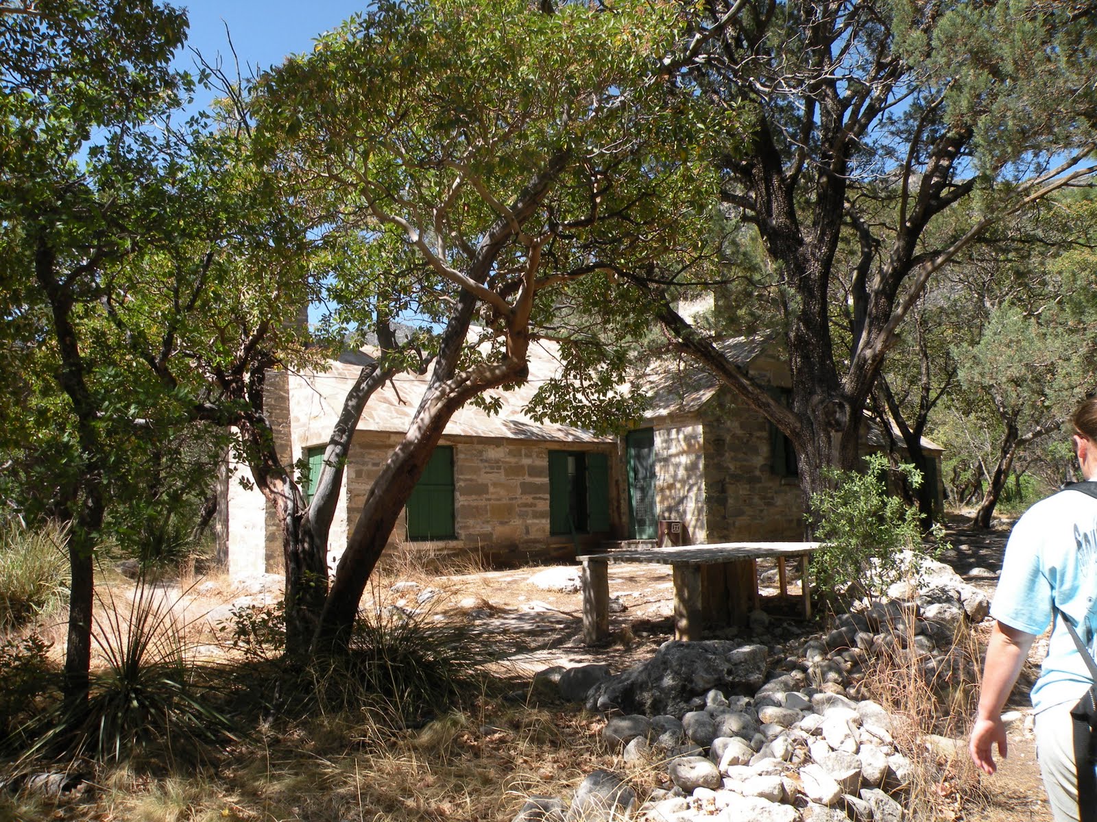
The cabin was built by Pratt as a getaway in his own private oasis in the desert. He had all the supplies brought in by horse and mule to prevent needing to harvest the trees and stone in the canyon and wreck the natural beauty. It is extra-unusual as the whole cabin is made of stone including the roof!

The trail there is about 2 miles (4 round trip) and is mostly flat so we made the trip in just a couple hours although it was still pretty painful to be honest. But to sit on the back porch of the cabin and feel the breeze blowing through the trees is an experience that is hard to duplicate. We made it back to the car just as the wind really started to kick up and then began the drive back to Midland. Overall, it was one of the best getaway weekends we've had in a long time, maybe since we left Colorado and I look forward to a return trip. (Probably in the Fall).

Thursday, 28 April 2011

Guadalupe Peak: Easter Weekend 2011 Part II


If you haven't read Part I of our trip, start here. After leaving Rattlesnake Springs we made a side-trip out to Sitting Bull Falls which I had heard was a great little hike and a work of the CCC-era park building program. After an hour or so of driving we found two regrettable things, it was $5 a car to enter, and it closed in 30 minutes. We opted to leave it to another day. I regret this deeply now because the Last Chance Fire that started Saturday is said to have greatly impacted the area and it may never be the same as it was on last Friday when we were there. But we left, and returned to Carlsbad for the night where we ate a fantastic dinner at Danny's BBQ and stayed at the brand new Fairfield Inn.

Saturday we woke up around 6AM and made our way down National Parks Hwy to Guadalupe Mountains National Park. We first went to the Visitor Center and stamped our passport to mark our 60th official National Park visited and got some information from the Rangers about camping options. We went to the Pine Springs Campground and chose a site, fixed some water and lunch for the hike and began our trek at approximately 10AM. The trail to Guadalupe Peak is mostly gravel and crushed rock with many switchbacks that slowly gain elevation until you transition from from the alluvial slopes into the bedrock of the Guads which happens to be a limestone reef composed not of coral like modern reefs but sponges, algae mats, brachipods, crinoids, and other manner of critters with preserved carbonate skeletons. El Capitan is the best known and most prominent outcrop of this reef, but it creates a horseshoe shaped atoll that the Guadalupe Mountains are but a small portion of.

After a mile or so the trail loses a lot of its steepness and the flora transitions from the desert scrub brush into pinon pine in what is known as a "floating island forest." The shade and extra breeze was wonderful and with temperatures in the high 70s I can't imagine much better weather for the hike. Even though the grade of the trail wasn't as steep we really started to feel the hike at this point, and even the sight of the Guadalupe Peak Campground almost wasn't enough to spur us on. We took a lot of breaks along the way, sometimes we snacked on granola and such, but mostly we drank water and Gatorade. The NPS suggests one Gallon of water per person per day on this trail. I drank 5 liters+ and Steph drank 2 liters+ during the course of our journey there and back again. Rounding the corner of the meadow the campground resides in we finally saw our goal before us. It bolstered our spirits but also dampened them just a bit because it was still a long ways up. We crossed the "highest bridge in Texas" which actually made us walk downhill into a saddle.

We lamented that we were going the wrong way, but passed a couple of hikers coming down from the summit that gave us words of encouragement that spurred us on. Many of these hikers had passed us on the way up; I never claimed to be athletic. The last mile is almost as bad as the first mile, there are maybe half as many switchbacks and the grade isn't as steep, but the trail is loose limestone chunks that are hard on the ankles. We summited the peak at about 3PM, five hours after we began!

The trail is a little over 4 miles long, 8 miles round trip so we didn't set any land-speed records but that was never our goal either. The important thing is we did it and the views we received were indescribable. If you are going to truly visit Guadalupe Mountains NP this is the hike you must do. We signed the mountain register, ate a small lunch, then crashed on a ledge for a while. The return hike was uneventful, we met a Ranger that had found a camera on the trail and was looking for the owner and a chatty Irishman that talked to himself in another language. (Presumably Irish?) We returned to the trail head at 7PM, a 9 hour hike! There isn't much else to say, we washed up and cooked some quick dinner before hitting the air mattress.

Tuesday, 26 April 2011

Where have we been?

When I mention National Parks as a hobby the first question I usually get is "How many have you been to?" Well I wasn't sure, and as you will see in a minute I am still not totally sure. Part of the reason is that the NPS is peculiar in how they list the properties they administrate, part is because there are a lot of affiliated parks that get some funding from the NPS but are not in the NPS, and lastly there are many NPS trails that are not counted as parks. All that said and after consulting the ever-knowing Wikipedia, I calculate we have visited 60 of the 394 National Parks Units.

Alabama
Horseshoe Bend NMP
Little River Canyon NP
Russell Cave NM
Arkansas
Fort Smith
Hot Springs NP
Colorado
Bent's Old Fort NHS
Black Canyon of the Gunnison NP
Colorado NM
Curecanti NRA
Florissant Fossil Beds NM
Great Sand Dunes NP & NP *(Counts as two parks)
Hovenweep NM
Mesa Verde NP
Rocky Mountains NP
Yucca House NM
Florida
Gulf Islands NS
Georgia
Chickamauga & Chattanooga NMP
Kansas
Brown vs Board of Education NHS
Louisiana
Jean Lafitte NHP & Preserve* (Many locations but one park)
New Orleans Jazz NHP
Mississippi
Natchez Trace Parkway
Natchez trace National Scenic Trail
Missouri
Jefferson National Expansion Memorial (St. Louis Arch)
Ulysses S. Grant NHS
Montana
Bighorn Canyon NRA
Nebraska
Agate Fossil Beds NM
Scotts bluff NM
New Mexico
Aztec Ruins Nm
Bandelier NM
Capulin Volcano NM
Carlsbad Caverns NP
Chaco Culture NHP
El Malpais NM
El Morro NM
Fort Union NM
Gila Cliff Dwellings NM
Pecos NHP
Petroglyph NM
North Carolina
Carl Sandburg Home NHS
Oklahoma
OKC Memorial *(No longer NPS but I still count it)
Puerto Rico
San Juan NHS
South Dakota
Badlands NP
Jewel Cave NM
Minuteman Missle NHS
Mount Rushmore NM
Wind Cave NP
Tennessee
Appalachian Trail
Blue Ridge Parkway
Great Smokey Mountains NP
Texas
Guadalupe Mountains NP *(#60 visited!)
San Antonio Missions NHP
Virgin Islands
Virgin Islands NP
Virgin Islands Coral Reef NM
Wyoming
Devils Tower NM
Fort Laramie NHS
Fossil Butte NM
Grand Teton NP
John D. Rockefeller Memorial Parkway
Yellowstone NP